No products in the cart.
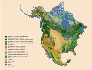
North American Land Change Monitoring System offers a product with a 30-meter spatial resolution 2010 landcover for North America. Created from a composite of images assembled from satellite observations (Landsat), this product was created through a tri-national collaborative effort that harmonized land cover classification systems from Canada, Mexico and the United States into 19 land cover classes, providing a uniform view of the continent at a consistent scale
30-m spatial resolution global forest canopy height map was developed through the integration of the Global Ecosystem Dynamics Investigation (GEDI) lidar forest structure measurements and Landsat analysis-ready data time-series (Landsat ARD).
There was a problem reporting this post.
Please confirm you want to block this member.
You will no longer be able to:
Please allow a few minutes for this process to complete.