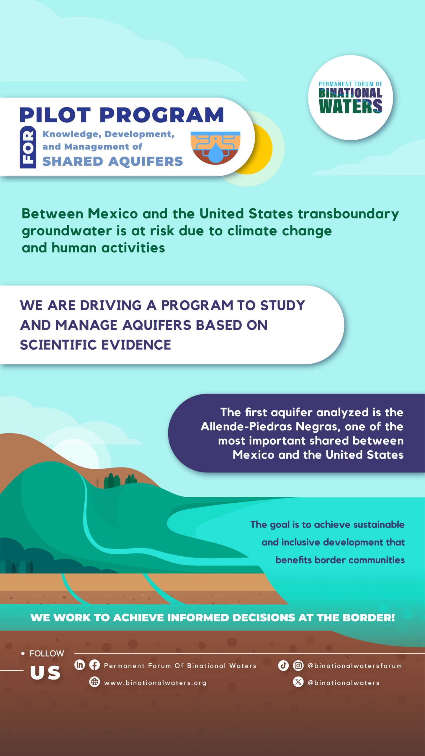
Transboundary water management: A transboundary Aquifers Pilot Program
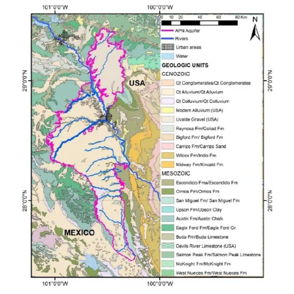
The Allende–Piedras Negras Transboundary Aquifer (APN-TBA) is located between the states of Texas (United States) and Coahuila (Mexico). The Rio Grande crosses the aquifer, serving as both a natural and political divide between the two countries.
However, it remains unclear whether the APN-TBA qualifies as a true transboundary aquifer flow system, which would require transboundary water management through joint or coordinated efforts by the two different administrative jurisdictions.
Learn more about the Signing of Minute 331 by visiting our dedicated information page.
Objective of the project
To develop a framework of transboundary cooperation to address transboundary water management issues along the US/Mexico border issues. The resulting framework will serve as a model and can be applied in other transboundary water basins and shared aquifers.
Specific Objectives
- To develop scientifically-based knowledge on assessment and management of transboundary aquifers specifically applied on the APN TBA between Coahuila and Texas.
- To develop specific feasible recommendations on water management strategies and short-term initiatives based on social and economic priorities and current and future water availability scenarios.
- Use this knowledge to support long-term sustainable economic development with social responsibility through inclusive decision-making process, transparency, stakeholder involvement and shared governance schemes.
- To develop strategies aligned to current ESG requirements and goals.
- To develop communication strategies to socialize and translate scientific findings into useful and executable information for different types of audiences and users.
- To build social capital and trust among involved institutions/stakeholders.
- Develop scientific binational publications on technical journals.
- To evaluate the feasibility to develop and maintain a groundwater monitoring network (public and accessible) for groundwater levels and water quality.
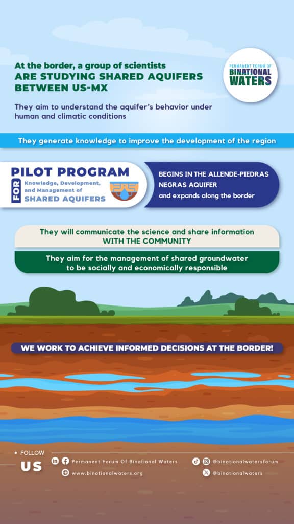
Transboundary Aquifers Pilot Program: Knowledge, development and management of shared aquifers
The 21st century sees the U.S.-Mexico borderlands facing an emerging array of water- resources management challenges. These challenges range from the increasing demand of water due to urbanization, industrialization, and agricultural expansion, to more drought prominent conditions.
This growing demand strains the capacity of limited water supplies to deal with a broad spectrum of social, legal, and environmental issues threatening surface and groundwater quality and border security. Droughts conditions across the border region, already decades-long, are likely to continue and intensify, and constrain even further the ability of the parties to meet water delivery obligations in the Colorado and Rio Grande rivers (Coronado et al. 2021, Renteria et al. 2022).

A required collaboration on transboundary waters
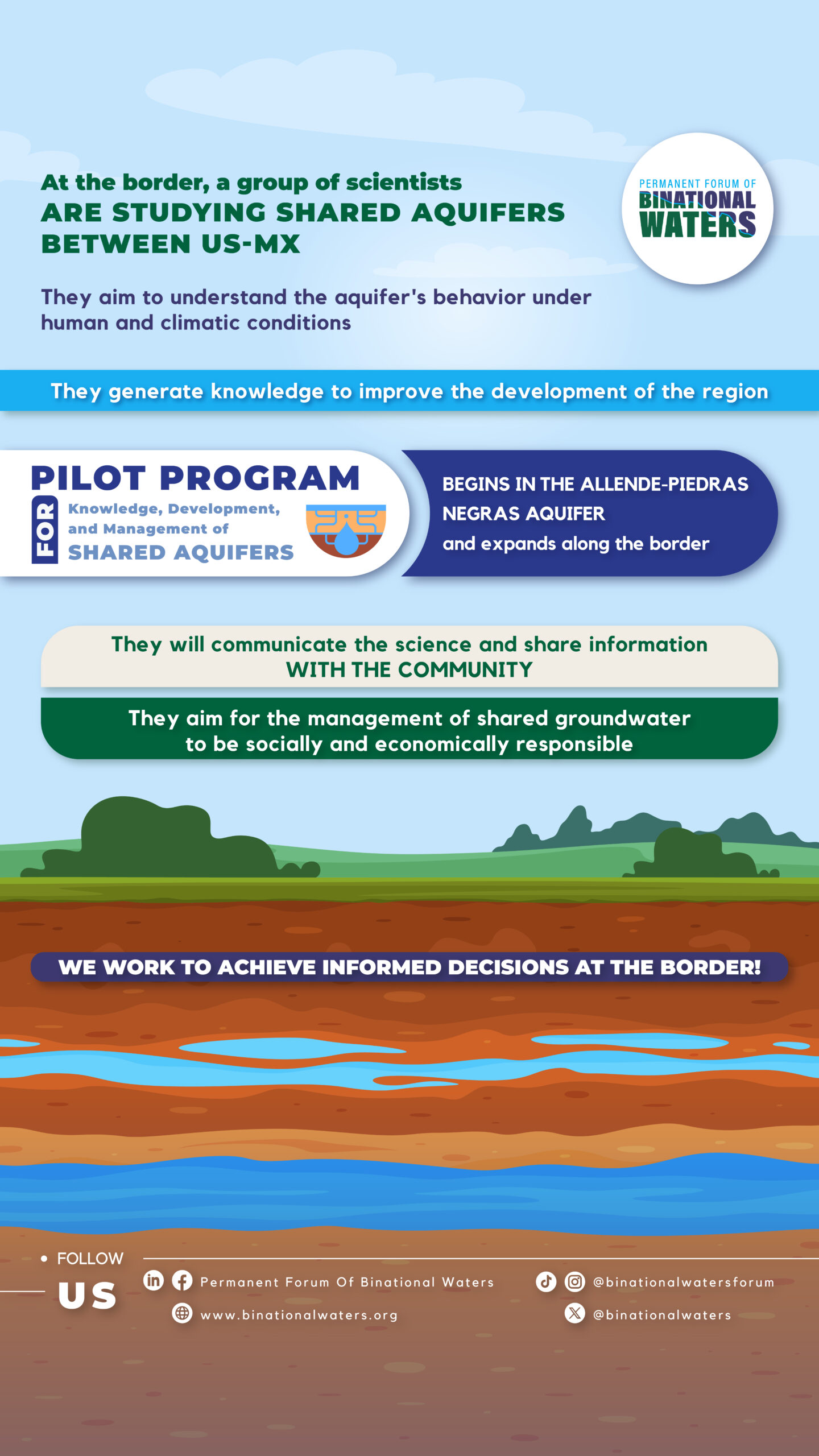
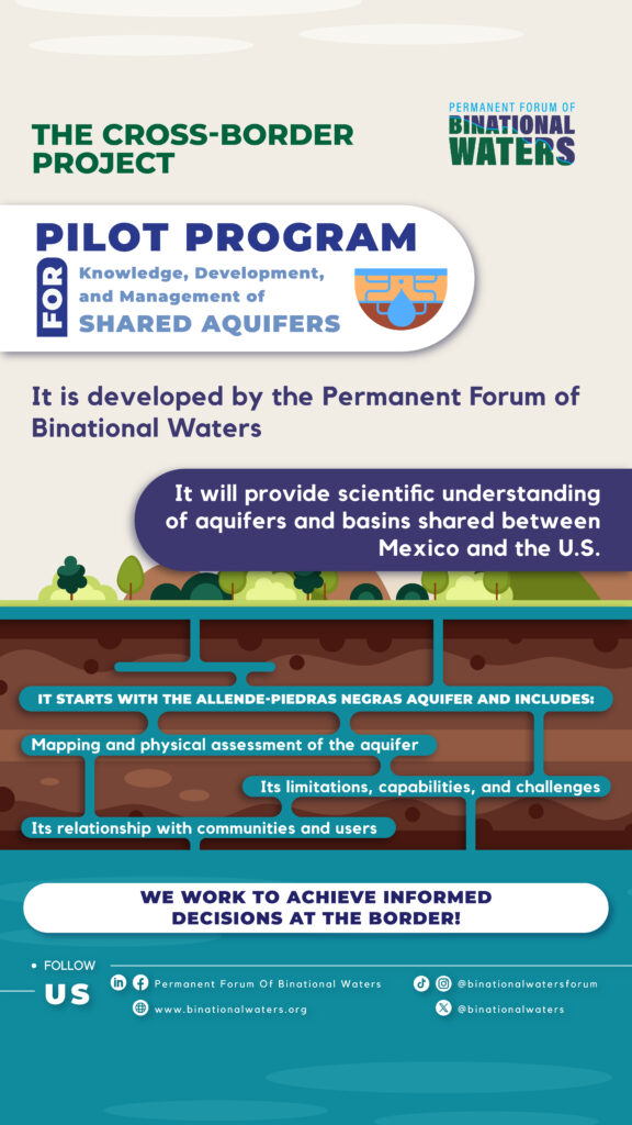
The need to regulate groundwater between Mexico and the United States requires information and research. The Transboundary Aquifer Pilot Program of the Allende-Piedras Negras aquifer offers an alternative and an opportunity to improve our shared aquifers.
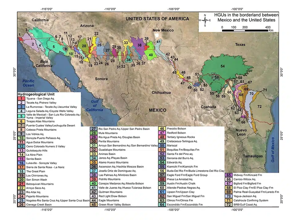
Up to 72 hydrogeological units have been identified along the very long border strip (ca 3,200 km) between Mexico and the United States; at least 28 are considered aquifers shared by the two countries (Sanchez et al., 2018; Sanchez & Rodriguez, 2021)
Shared waters, shared issues
In basins and aquifers that are shared by two or more countries, the unsustainable use of surface and groundwater on one side, can generate negative effects on water quantity and/or quality in the neighboring country, which in turn can cause harmful environmental and socioeconomic effects. These effects were shown in a global study of TBAs with aquifer stress indicators using groundwater abstraction, groundwater recharge, and groundwater contribution to environment flow, (Wada and Heinrich, 2013).
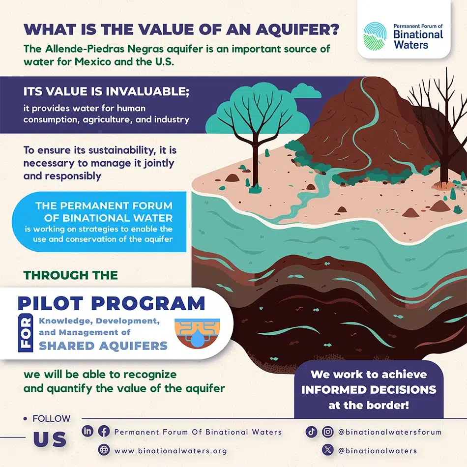
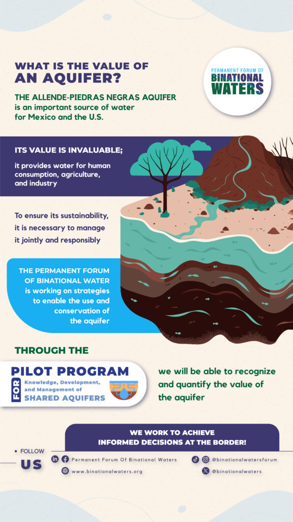
The Allende-Piedras Negras aquifer is an invaluable water source for both Mexico and the U.S., providing essential water for human consumption, agriculture, and industry. To ensure its sustainability, it must be responsibly managed through a collaborative approach.
The Permanent Forum of Binational Waters is working on strategies for the sustainable use and conservation of this aquifer. With the Shared Aquifers Knowledge, Development, and Management Pilot Program, we can recognize and quantify its true value.
As the demand for water increases with economic development and population growth, competition for the vital resource becomes greater. It has been reported that competition for water, i.e., for shared sources, can lead to serious conflicts both at domestic and international scale. Though at the same time, this same condition offers the opportunity of bringing stakeholders to the negotiation table as water becomes a strategic and national security resource (Subramanian & Wolf 2012; Wolf 1999). Within this context, transboundary aquifers (TBAs) raise questions about their sustainable management, the fair distribution of water, and transboundary effects among the countries that share them, and at the same time, becomes a tool to promote cooperation and peace.
In addition, limited knowledge of TBAs in most regions of the world poses a problem of planning and developing shared groundwater resources. A lack of adequate, long-term groundwater monitoring is also a common obstacle to the comprehensive assessment of TBAs (Rivera et al., 2022). With limited knowledge, threats on groundwater security are perceived (sometimes wrongly), including its unsustainable use, decreased recharge rates, and even conflicts. Thus, reaching conflict-free joint governance of a TBA, to bring about equitable and sustainable use of the resource, requires a three-pillar framework, including the physical assessment of the TBA, cooperation and collaboration mechanisms, and shared management (Rivera et al., 2022).
The current water condition along the MX-U.S. border
Continued drought conditions are generating internal and bilateral tensions as competing water users in Mexico and the United States struggle to meet their needs. More frequent flooding events result in threats to critical border water infrastructure, heightened sanitation and public health issues, as well as greater contamination of transboundary water bodies.
Tension over the use of shared transboundary groundwater is increasingly apparent as the lack of clear guidelines over its management collides with a greater demand for this resource. Recent tension over the allocation of water resources (Mumme, 2021) is a harbinger of a future where competition over unreliable water supplies will intensify (Figure 1.2 shows two of the most important TBA’s cases along the border). Meeting these challenges requires innovative and strategic thinking, recognizing the complex and dynamic interaction between coupled environmental forces and socio-economic systems in the border region.
Integrated studies required for transboundary aquifers (TBAs)
TBAs are of vital importance for Mexico and the USA because, for at least twelve sister cities, they are the main source of water for domestic use, for the ‘maquiladoras’ industry as well as for the agricultural sector. Both countries have carried out studies of their share of few of these aquifers. On an intermittent basis, exchange of basic isolated information and the results of a couple of studies (San Pedro and Santa Cruz, Mesilla and Hueco Bolson) has been carried out in order to identify existing or potential transboundary effects, to mitigate or prevent them, but not much on the design of potential joint management plans. The results have been exchanged intermittently, but have not yet been integrated, reconciled, or translated into formal binational management agreements, data sharing, or sustainability plans.
From all the above, the necessity of jointly undertaking, or accelerating, integrated studies of TBAs along the US/Mexico border is clear (Rivera and Hanson, 2022). These studies shall have a solid technical basis to support strategies for sustainable binational management of priority aquifers and, eventually, to result in an agreement (formal) or set of arrangements (informal), or on a case-by-case basis scheme, which could be reconciled through interpretations or additions (i.e., Minutes) to the existing 1944 treaty on the waters of the Colorado, Tijuana, and Grande/Bravo Rivers.
Pilot Project: A Solution to the Transboundary Hydrological Enigma
The Allende–Piedras Negras Transboundary Aquifer (APN-TBA) is the pilot project and potential model for other transboundary aquifers (TBA) along the US-Mexico Border. Because of its location on the political border, the APN-TBA has a strategic value to binational relationships since it provides 85% of the total water needs in the region. From this percentage of groundwater use, approximately 70% is used by agriculture, 16% by industry, 5% by public supply, and the remaining 9% is used by rural households (Rodriguez et al., 2020).
The knowledge acquired with this pilot project will be used to frame a vision of long-term sustainable development with social responsibility, including open communication, visibility, stakeholders’ involvement, and shared governance; all these supported with scientific tools.
Download all the deliverables available of the project
These resources provide an overview of transboundary surface and groundwater conditions, focusing on socio-economic factors, governance structures, and research gaps in the region.
The documents are foundational for advancing through the next phases of this project aimed at sustainable water management.
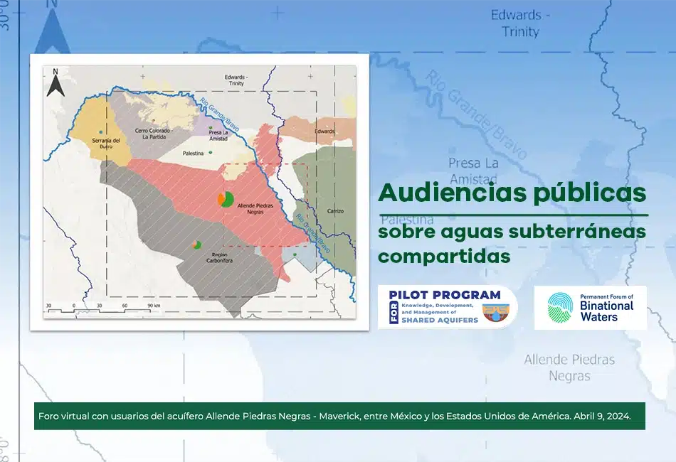
Public hearings on shared groundwater
Public hearings on shared groundwater
Graphic for the presentation
Users of the Allende Piedras Negras – Maverick aquifer, between Mexico and the United States of America, participate in public hearings held on April 9, 2024.
Graphic for summary
Summary of the first public hearing on the TBA aquifer Allende Piedras Negras – Maverick. Download the brief document of the session held on April 9, 2024.
Synthesis of the current situation
Synthesis of the current situation
General graphic
As part of the first phase of the Allende-Piedras Negras Transboundary Aquifer Pilot Program, several key documents have been published.
Annex A - Technical Report
A detailed synthesis of data gaps, research needs, and the physical state of the aquifer system.
Annex B - References
A compilation of scientific studies on geology, groundwater, and environmental conditions in the region.
Annex C - Collected Data
All collected data, including geology, hydrology, and environmental information for the region.
Synthesis report on water supply and demand. Knowledge of the physical conditions of groundwater and aquifers in the study area
Read the mayor findings and key recommendations.
Why Water Security Matters for the Border
Water security at the Mexico-U.S. border is critical for the health and economic prosperity of millions of people who rely on these shared resources. Ensuring a reliable supply of clean water supports agricultural productivity, industrial activities, and domestic use, while also protecting biodiversity and maintaining ecosystem health.
Without a coordinated approach to managing these resources, both countries could face significant social, economic, and environmental challenges.By supporting initiatives focused on water security along the Mexico-U.S. border, your organization can help safeguard these vital resources for future generations.
Transboundary Aquifers Pilot Program: Knowledge, development and management of shared aquifers
The 21st century sees the U.S.-Mexico borderlands facing an emerging array of water- resources management challenges. These challenges range from the increasing demand of water due to urbanization, industrialization, and agricultural expansion, to drought prone conditions. This growing demand strains the capacity of limited water supplies to deal with a broad spectrum of social, legal, and environmental issues threatening surface and groundwater quality and border security. Droughts across the region, already decades-long, are likely to continue and intensify, and constrain even further the ability of the parties to meet water delivery obligations in the Colorado and Rio Grande rivers (Coronado et al. 2021, Renteria et al. 2022).
A required collaboration on transboundary waters
The need to regulate groundwater between Mexico and the United States requires information and research. The Transboundary Aquifer Pilot Program of the Allende-Piedras Negras aquifer offers an alternative and an opportunity to improve our shared groundwater.
Up to 72 hydrogeological units have been identified along the very long border strip (ca 3,200 km) between Mexico and the United States; at least 28 are considered aquifers shared by the two countries (Sanchez et al., 2018; Sanchez & Rodriguez, 2021) (Figure 1.1). For some 80 years, the distribution and management of surface waters in the major basins they share – those of the Colorado, Grande/Bravo, and Tijuana Rivers – have been regulated by international treaties. However, in the area of groundwater, only one agreement has been concluded (Minute 242, IBWC, 1973), which limits groundwater extraction in the shared Yuma/Mexicali-area aquifers, and establishes obligations of mutual consultation if one of them intends to carry out actions that could have harmful effects on the other side of the border.

Figure 1.1. Hidrogeological units between Mexico and the United States of America. Source: Sanchez and Rodriguez (2022)
Shared waters, shared issues
In basins and aquifers that are shared by two or more countries, the conjunctive use of surface and groundwater in one of them can generate negative effects on water quantity and/or quality in the neighboring country, which in turn can cause harmful environmental and socioeconomic effects. These effects were shown in a global study of TBAs with aquifer stress indicators using groundwater abstraction, groundwater recharge, and groundwater contribution to environment flow, as indicated in Figure 1.2 (Wada and Heinrich, 2013). As the demand for water increases with economic development and population growth, competition for the vital resource becomes greater. It has been written that competition for water, i.e., for shared sources, can lead to serious conflicts and even wars. Though at the same time, this same condition is bringing stakeholders to the negotiation table as water becomes a strategic and national security resource (Subramanian & Wolf 2012; Wolf 1999). Within this context, transboundary aquifers (TBAs) raise questions about their sustainable management, the fair distribution of water, and transboundary effects among the countries that share them.
In addition, limited knowledge of TBAs in most regions of the world poses a problem of planning and developing shared groundwater resources. A lack of adequate, long-term groundwater monitoring is also a common obstacle to the comprehensive assessment of TBAs (Rivera et al., 2022). With limited knowledge, threats on groundwater security are perceived (sometimes wrongly), including its unsustainable use, decreased recharge rates, and even conflicts. Thus, reaching conflict-free joint governance of a TBA, to bring about equitable and sustainable use of the resource, requires a three-pillar framework, including the physical assessment of the TBA, cooperation and collaboration mechanisms, and shared management (Rivera et al., 2022).
The current water condition along the MX-U.S. border
Continued drought conditions are generating internal and bilateral tensions as competing water users in Mexico and the United States struggle to meet their needs. More frequent flooding events result in threats to critical border water infrastructure, heightened sanitation and public health issues, as well as greater contamination of transboundary water bodies. Tension over the use of shared transboundary groundwater is increasingly apparent as the lack of clear guidelines over its management collides with a greater demand for this resource. Recent tension over the allocation of water resources (Mumme, 2021) is a harbinger of a future where competition over unreliable water supplies will intensify (Figure 1.2 shows two of the most important TBA’s cases along the border). Meeting these challenges requires innovative and strategic thinking, recognizing the complex and dynamic interaction between coupled environmental forces and socio-economic systems in the border region.
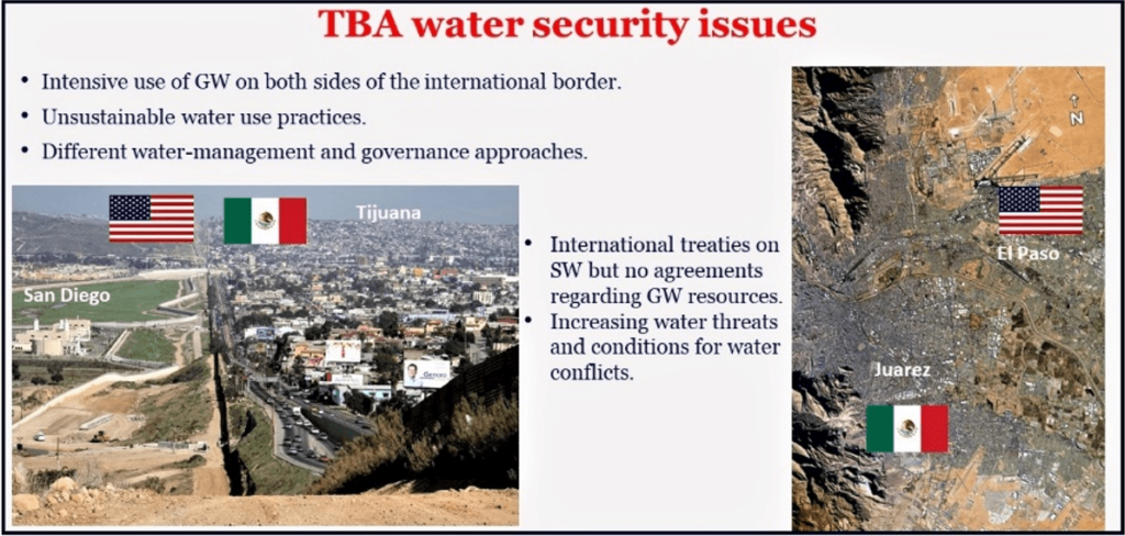
Figure 1.2. Water security issues. Source: Rivera (2020)
Integrated studies required for transboundary aquifers (TBAs)
TBAs are of vital importance for Mexico and the USA because, for at least twelve sister cities, they are the main source of water for domestic use, for the ‘maquiladoras’ industry as well as for the agricultural sector. Both countries have carried out studies of their share of few of these aquifers. On an intermittent basis, exchange of basic isolated information and the results of a couple of studies (San Pedro and Santa Cruz, Mesilla and Hueco Bolson) has been carried out in order to identify existing or potential transboundary effects, to mitigate or prevent them, but not much on the design of potential joint management plans. The results have been exchanged intermittently, but have not yet been integrated, reconciled, or translated into formal binational management agreements, data sharing, or sustainability plans.
From all the above, the necessity of jointly undertaking, or accelerating, integrated studies of TBAs along the US/Mexico border is clear (Rivera and Hanson, 2022). These studies shall have a solid technical basis to support strategies for sustainable binational management of priority aquifers and, eventually, to result in an agreement (formal) or set of arrangements (informal), or on a case-by-case basis scheme, which could be reconciled through interpretations or additions (i.e., Minutes) to the existing 1944 treaty on the waters of the Colorado, Tijuana, and Grande/Bravo Rivers.
Pilot Project: A Solution to the Transboundary Hydrological Enigma
The Allende–Piedras Negras Transboundary Aquifer (APN-TBA) will be the pilot project and potential model for other transboundary aquifers (TBA) along the US-Mexico Border. Because of its location on the political border, the APN-TBA has a strategic value to binational relationships since it provides 85% of the total water needs in the region. From this percentage of groundwater use, approximately 70% is used by agriculture, 16% by industry, 5% by public supply, and the remaining 9% is used by rural households (Rodriguez et al., 2020).
The knowledge acquired with this pilot project will be used to frame a vision of long-term sustainable development with social responsibility, including open communication, visibility, stakeholders’ involvement, and shared governance; all these supported with scientific tools.
Do you want to know the most relevant things and news about this project?
- Home
- Press
- Project
- Partners
- Acronyms
- References
- Contact
- Workshop
Transboundary Aquifers Pilot Program: Knowledge, development and management of shared aquifers
The 21st century sees the U.S.-Mexico borderlands facing an emerging array of water- resources management challenges. These challenges range from the increasing demand of water due to urbanization, industrialization, and agricultural expansion, to drought prone conditions. This growing demand strains the capacity of limited water supplies to deal with a broad spectrum of social, legal, and environmental issues threatening surface and groundwater quality and border security. Droughts across the region, already decades-long, are likely to continue and intensify, and constrain even further the ability of the parties to meet water delivery obligations in the Colorado and Rio Grande rivers (Coronado et al. 2021, Renteria et al. 2022).
A required collaboration on transboundary waters
The need to regulate groundwater between Mexico and the United States requires information and research. The Transboundary Aquifer Pilot Program of the Allende-Piedras Negras aquifer offers an alternative and an opportunity to improve our shared groundwater.
Up to 72 hydrogeological units have been identified along the very long border strip (ca 3,200 km) between Mexico and the United States; at least 28 are considered aquifers shared by the two countries (Sanchez et al., 2018; Sanchez & Rodriguez, 2021) (Figure 1.1). For some 80 years, the distribution and management of surface waters in the major basins they share – those of the Colorado, Grande/Bravo, and Tijuana Rivers – have been regulated by international treaties. However, in the area of groundwater, only one agreement has been concluded (Minute 242, IBWC, 1973), which limits groundwater extraction in the shared Yuma/Mexicali-area aquifers, and establishes obligations of mutual consultation if one of them intends to carry out actions that could have harmful effects on the other side of the border.
Figure 1.1. Hidrogeological units between Mexico and the United States of America. Source: Sanchez and Rodriguez (2022)
Shared waters, shared issues
In basins and aquifers that are shared by two or more countries, the conjunctive use of surface and groundwater in one of them can generate negative effects on water quantity and/or quality in the neighboring country, which in turn can cause harmful environmental and socioeconomic effects. These effects were shown in a global study of TBAs with aquifer stress indicators using groundwater abstraction, groundwater recharge, and groundwater contribution to environment flow, as indicated in Figure 1.2 (Wada and Heinrich, 2013). As the demand for water increases with economic development and population growth, competition for the vital resource becomes greater. It has been written that competition for water, i.e., for shared sources, can lead to serious conflicts and even wars. Though at the same time, this same condition is bringing stakeholders to the negotiation table as water becomes a strategic and national security resource (Subramanian & Wolf 2012; Wolf 1999). Within this context, transboundary aquifers (TBAs) raise questions about their sustainable management, the fair distribution of water, and transboundary effects among the countries that share them.
In addition, limited knowledge of TBAs in most regions of the world poses a problem of planning and developing shared groundwater resources. A lack of adequate, long-term groundwater monitoring is also a common obstacle to the comprehensive assessment of TBAs (Rivera et al., 2022). With limited knowledge, threats on groundwater security are perceived (sometimes wrongly), including its unsustainable use, decreased recharge rates, and even conflicts. Thus, reaching conflict-free joint governance of a TBA, to bring about equitable and sustainable use of the resource, requires a three-pillar framework, including the physical assessment of the TBA, cooperation and collaboration mechanisms, and shared management (Rivera et al., 2022).
The current water condition along the MX-U.S. border
Continued drought conditions are generating internal and bilateral tensions as competing water users in Mexico and the United States struggle to meet their needs. More frequent flooding events result in threats to critical border water infrastructure, heightened sanitation and public health issues, as well as greater contamination of transboundary water bodies. Tension over the use of shared transboundary groundwater is increasingly apparent as the lack of clear guidelines over its management collides with a greater demand for this resource. Recent tension over the allocation of water resources (Mumme, 2021) is a harbinger of a future where competition over unreliable water supplies will intensify (Figure 1.2 shows two of the most important TBA’s cases along the border). Meeting these challenges requires innovative and strategic thinking, recognizing the complex and dynamic interaction between coupled environmental forces and socio-economic systems in the border region.
Figure 1.2. Water security issues. Source: Rivera (2020)
Integrated studies required for transboundary aquifers (TBAs)
TBAs are of vital importance for Mexico and the USA because, for at least twelve sister cities, they are the main source of water for domestic use, for the ‘maquiladoras’ industry as well as for the agricultural sector. Both countries have carried out studies of their share of few of these aquifers. On an intermittent basis, exchange of basic isolated information and the results of a couple of studies (San Pedro and Santa Cruz, Mesilla and Hueco Bolson) has been carried out in order to identify existing or potential transboundary effects, to mitigate or prevent them, but not much on the design of potential joint management plans. The results have been exchanged intermittently, but have not yet been integrated, reconciled, or translated into formal binational management agreements, data sharing, or sustainability plans.
From all the above, the necessity of jointly undertaking, or accelerating, integrated studies of TBAs along the US/Mexico border is clear (Rivera and Hanson, 2022). These studies shall have a solid technical basis to support strategies for sustainable binational management of priority aquifers and, eventually, to result in an agreement (formal) or set of arrangements (informal), or on a case-by-case basis scheme, which could be reconciled through interpretations or additions (i.e., Minutes) to the existing 1944 treaty on the waters of the Colorado, Tijuana, and Grande/Bravo Rivers.
Pilot Project: A Solution to the Transboundary Hydrological Enigma
The Allende–Piedras Negras Transboundary Aquifer (APN-TBA) will be the pilot project and potential model for other transboundary aquifers (TBA) along the US-Mexico Border. Because of its location on the political border, the APN-TBA has a strategic value to binational relationships since it provides 85% of the total water needs in the region. From this percentage of groundwater use, approximately 70% is used by agriculture, 16% by industry, 5% by public supply, and the remaining 9% is used by rural households (Rodriguez et al., 2020).
The knowledge acquired with this pilot project will be used to frame a vision of long-term sustainable development with social responsibility, including open communication, visibility, stakeholders’ involvement, and shared governance; all these supported with scientific tools.
Do you want to know the most relevant things and news about this project?
What is the TAPP project?
The APN Transboundary Aquifers Pilot Project (TAPP) aims to collaborate on joint solutions in a binational manner, ensuring informed decisions are made by the governments on both sides of the border.

 The APN Transboundary Aquifers Pilot Project aims to collaborate on joint strategies at binational scale, ensuring informed decisions are made by stakeholders on both sides of the border.
 The Permanent Forum of Binational Waters is working on a cross-border project to raise awareness about conservation of shared aquifers between Mexico and the United States.
 A shared resource like an aquifer needs to be managed using both the physical science and the social science to preserve its richness and socio-political values across different cultures and stakeholders.
 For a responsible management of shared groundwater, scientists on both sides of the border study the behavior of the Allende-Piedras Negras aquifer to raise awareness about water conservation.

The APN Transboundary Aquifers Pilot Project aims to collaborate on joint strategies at binational scale, ensuring informed decisions are made by stakeholders on both sides of the border.
The Permanent Forum of Binational Waters is working on a cross-border project to raise awareness about conservation of shared aquifers between Mexico and the United States.
A shared resource like an aquifer needs to be managed using both the physical science and the social science to preserve its richness and socio-political values across different cultures and stakeholders.

For a responsible management of shared groundwater, scientists on both sides of the border study the behavior of the Allende-Piedras Negras aquifer to raise awareness about water conservation.
Borderflow: Exploring an aquifer to create a Model
The Allende–Piedras Negras Transboundary Aquifer Pilot Project
The Allende–Piedras Negras Transboundary Aquifer (APN-TBA) aquifer is located between the states of Texas (United States) and Coahuila (Mexico) (Figure 2.1). The Rio Grande crosses the aquifer, acting as a natural and political divide between the two countries. However, it remains unclear whether the APN-TBA can be considered a truly transboundary aquifer flow system, which would potentially require joint or coordinated management by two different administrative jurisdictions.
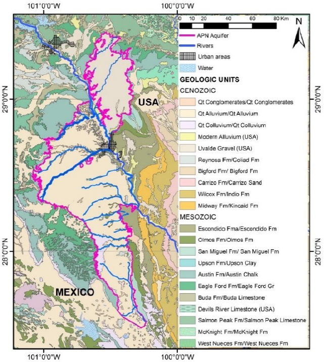
Figure 2.1. The Allende – Piedras Negras Transboundary
Aquifer. Source: Rodriguez et al. (2020)
Recently, a numerical model was developed for the APN-TBA (Figure 2.2), whose simulations numerically demonstrated that there is probably cross-boundary flow between the U.S. and the Mexico regions of the aquifer categorizing it as transboundary (Rodriguez et al., 2020).
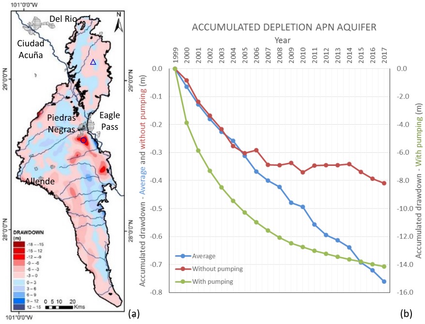
Figure 2.2. Allende Piedras Negras aquifer modeled
drawdown between January 2000 and December 2017.
Source: Rodriguez et al. (2020)
Notwithstanding, the simulated area is rather local, and the layers considered in that study are the shallow aquifers. Therefore, important questions remain on the APN-TBA project at the intermediate and regional scales, as well as the vertical scale of the deeper layers and aquifers. Further, some key processes are not included in the model, such as the effects of fracking, surface water/groundwater interaction, natural climatic variations, and effects of over-pumping on both sides of the border.
The existing APN-TBA model does not include the full spectrum of horizontal and vertical scales on both sides of the border; thus, the scales of the dynamics of groundwater (i.e., use and movement) either as a flux or in storage, and the eventual impacts of over-exploitation, in a larger area cannot be assessed with the current version of the model.
The major cities of interest in the region are Zaragoza, Morelos, Allende, Villa Union, Nava, El Moral, Guerrero, and Piedras Negras on the Mexico side (State of Coahuila). The U.S. side has Quemado, Spofford, Brackettville, and Eagle Pass as its main cities. Piedras Negras and Eagle Pass stand as the biggest urban centers in the area, with a total population of 271,410 (2020 census).
Due to the growing groundwater dependency in the region for its economic activities, restrictions on water extraction were established for the APN-TBA on the Mexican side due to the high risk of overexploitation and the low recharge rates owing to the semi-arid climatic conditions (DOF, 2013).
The Allende–Piedras Negras Transboundary Aquifer Pilot Project
To develop a framework of transboundary cooperation to address transboundary water issues along the US/Mexico border issues. The resulting framework will serve as a model and can be applied in other transboundary water basins.
To develop scientifically-based knowledge on assessment and management of transboundary aquifers specifically applied on the APN TBA between Coahuila and Texas.
To develop specific feasible recommendations on water management strategies and short-term initiatives based on social and economic priorities and current and future water availability scenarios.
Use this knowledge to support long-term sustainable economic development with social responsibility through inclusive decision-making process, transparency, stakeholder involvement and shared governance schemes.
To develop strategies aligned to the current ESG requirements and goals.
To develop communication strategies to socialize and translate scientific findings into useful and executable information for different types of audiences and users.
To build social capital and trust among involved institutions/stakeholders.
Develop scientific binational publications on technical journals.
To evaluate the feasibility to develop and maintain a groundwater monitoring network (public and accessible) for groundwater levels and water quality.
Proposed study zone and scales
Three different extents will be used to assess nested watersheds and aquifers framework and groundwater flow systems (Figure 2.3):
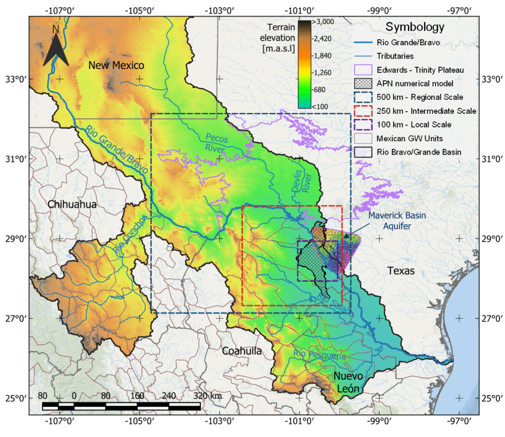
Figure 2.3. Synoptic region to be studied in the pilot project
Use GRACE signals to evaluate regional groundwater-storage changes for the periods 2002-2017 and 2018-2022.
Assess flow rates from the Pecos, Devils and Grande rivers.
Apply structural and sedimentary geology to evaluate the regional-scale geology
Generate 2D cross sections to define hydrostratigraphic units at 1000-m depth.
Assess potential and actual evapotranspiration and surface hydrological components using remote sensing data (e.g., CHIRPS, MODIS, DAYMET, BCM etc.).
Generate the DEM.
Refine the 2D cross sections and hydrostratigraphic units. These sections will be used to display and communicate results in digital format.
Evaluate vertical recharge using physically-based and/or water-budget models (e.g., EALCO, SWB Model, BCM model, or similar).
Identified/design groundwater flow system (GWFS) with distinct geological, topographical, geomorphological and climatic features mostly based on groundwater discharge, and in some cases a combination of areas of groundwater recharge and discharge.
Assess groundwater residence times using GW dating, when available, or with analytical solutions.
Project phases
The specific objectives of the APN-TBA pilot project are divided into four phases:
Prepare an executive synthesis of the current situation of the transboundary surface and groundwater conditions centered around Piedras Negras/Eagle Pass region. This synthesis will provide an overview of current socio-economic conditions, analysis of existing governance arrangements in place for managing water (a stakeholder mapping of existing public-private relationships). The most pressing issues, physical and socio-economic elements, as well as governance and policy challenges, will be addressed to provide a full contextual scan of the system from a broad scale. Identification of data gaps and priorities accordingly.
Proposed activities
- Prepare an executive synthesis of the current situation of the transboundary surface and groundwater conditions centered around Piedras Negras/Eagle Pass region.
- Overview of the socio-economic current conditions, stakeholder mapping, needs, priorities and public-private relationships. Most pressing issues, physical and socio-economic elements as well as governance and policy challenges will be addressed to provide a picture of the system from a broad scale.
- Conduct an analysis of existing institutional and governance architectures for managing water in the regio:a. Identify existing binational and domestic institutions and their respective laws and regulations for managing cross-border water resources;
b. Identify existing mechanisms for (1) domestic and cross-border stakeholder participation; and (2) data/information collection, sharing, and dissemination;
c. Evaluate institutions, stakeholder participation and information-sharing mechanisms through application of water governance indicator matrix and gap analysis.
- Overview of the international cooperation of this transboundary aquifer.
- Communicate proposal’s objectives to main stakeholders to seek support and endorsement of the project, and get their feedback on expected outcomes. Schedule follow up interviews and workshops to communicate advances, changes, and improvements to the project.
- Identification of main data gaps, research needs, and research priorities.
- Research gaps will be translated into further research needs and significance of those future steps for the overall objectives of the project.
- Research needs will be translated into potential impacts and short and long term specific measurable actions at different levels of governance systems.
Results
Annex A_Extensive Technical Report of Data Gaps, Information and Research Needs: Allende Piedras Negras-Maverick Transboundary Aquifer
This report is part of the Allende-Piedras Negras Transboundary Aquifer (APN-TBA) Pilot Project, a project of the Permanent Forum of Binational Waters (PFBW). This project is intended to provide scientifically-based knowledge on transboundary aquifers and watersheds, and transboundary groundwater and surface water using a holistic approach on the assessment and management of transboundary aquifers toward their sustainable development.
The objective of this report is to integrate existing data and information from previous geological, hydrogeological, geochemical, and environmental studies of the APN-TBA, in order to develop an integrated dataset for study of the full aquifer system. This report represents Annex A, it should be consulted together with the two other Annexes, B and C. The three annexes constitute a comprehensive review of previous and current data, information, and a variety of studies of the APN-TBA on both sides of the Mexico/US border. These have been compiled, analyzed, and are synthesized in this report; thus, this deliverable represents a synthesis of knowledge on the aquifer as per 2024.
Download the full Annex A here
Annex B_References of Technical Report
This document is the Annex B entitled “Main data, gaps, and research needs” which is part of the Allende-Piedras Negras Transboundary Aquifer (APN-TBA) Pilot Project, a project of the Permanent Forum of Binational Waters (PFBW).
This Annex lists the most relevant literature, scientific manuscripts, and technical reports to describe six domains of information, including geology, hydrogeology, groundwater, surface water, hydrogeochemical, and environment characteristics of the transboundary region formed by the limits of the Allende-Piedras Negras (APN) aquifers, Región Carbonífera, Serranía del Burro, Cerro Colorado – La Partida, Palestine, and Hidalgo, in Mexico; and the Edwards – Trinity, and Carrizo, in the U.S.A. These aquifers cover three spatial scales of analysis: a regional scale (500 km), an intermediate scale (250 km), and the local scale (100 km), which can be consulted in the Executive Report or Annex A – Extensive Technical Report.
Download the full Annex B here.
Annex C_Collected Data and Information
This document describes the data and information collected for the purpose of this project. The project’s database contains a comprehensive list of the retrieved information used to produce the extensive technical report, with technical information divided into eight categories: Geology, Hydrogeology, Surface water, Groundwater, Hydro-geochemistry, Environment, Remote Sensing, and Figures. Each domain in the database has a brief summary of its contents, along with information on the institutions from which the data was retrieved and the access URL links. The collected information for each domain is described on the corresponding Table the Annex.
Develop an initial conceptual model of hydrogeology, climate, and sustainability of water resources including: data compilation, identification of data gaps, analysis of existing data, and assessment of the suitability of existing monitoring networks. Data collection and methods assessment to evaluate the physical and managed water systems, as well as the relevance of current public policies on groundwater.
Proposed activities
Define the main issues and questions the pilot project will seek to resolve both on the physical and socio-economic conditions of the aquifer-system and with respect to shared management of the resource.
Collect and integrate hydrological, geological, geochemical, and hydrogeological data and information REPDA, SINA-CONAGUA, INEGI (LAYERS), data from TWDB/USGS/IBWC-CILA, CB, INEGI, and other related state and federal institutions.
Perform punctual field work to fill in knowledge gaps (physical, environmental, social, economical, and governance/policy data).
Perform analysis from existing data in support of development of the conceptual models where possible.
Build watershed and hydrogeological conceptual models of the transboundary groundwater flow systems in a multi-aquifers framework centered around both sides of the US/Mexico border in Piedras Negras (MX)/Eagle Pass (US), including:
a. Edwards-Trinity Plateau
b. Rio Grande Systems
c. Pecos and Devils Rivers
d. Allende – Piedras Negras/Eagle Pass
e. Maverick Basin Aquifer
f. Region Carbonifera
Develop a recharge/runoff model and groundwater modeling, and evaluate supply-and-demand components of historical periods, effects on river flows from groundwater extractions, water quality, and changes in rates of transboundary water flows. Environmental, water availability, and socio-economic risk assessment analysis to be conducted. Simultaneously, undertake full characterization of uncertainties present in the basin (natural, socio-cultural, governance and technical).
Proposed activities
Build a numerical model based on the conceptual model.
a. Use the model to simulate stresses, transboundary fluxes, indicators (e.g., GW stress, GW sustainability, degree of transboundariness) and future management and climate scenarios.
b. Define, simulate, and evaluate in more refined or nested models, critical subregions that may be subject to overexploitation or unsustainable uses or triggering secondary effects such as surface-water capture, interference with other groundwater uses, or water-quality degradation.
c. Use the model to evaluate possible sustainable scenarios.
d. Use the model results to develop a risk assessment analysis (water availability, environmental, socio-economic)
Use the strategy developed in this pilot project as a detailed example for all other TBAs located along the U.S./Mexico border.
Use the results of Phases 1-to-3 to develop governance- and related policy-proposals for the sustainable management and use of the APN-TBA, to assure a socially and economically responsible use of water resources considering both its domestic and transboundary characteristics and socio-economic and institutional implications.
Proposed activities
Develop governance and related policy proposals for the sustainable management and use of the APN-TBA, to assure socially and economically responsible scenarios.
a. If appropriate, propose new institutions, priorities, regulations/laws and/or responsibilities (or, modifications) at both levels of governance
b. If appropriate, propose new mechanisms for stakeholder participation and information sharing at both national and binational levels of governance
c. Evaluate economic impact assessment of different groundwater availability scenarios (risk assessment analysis)
d. Evaluate the socio-economic impact on GW governance by different model scenarios (risk assessment analysis)
e. Development of a conceptual model of the socio-environmental system
f. Sustainability of groundwater management according to levels of transparency, inclusion, and groundwater governance.
What will this project bring?
The goals for the short, medium, and long terms, are described below in detail. These goals are designed to address the main issues and questions the pilot project will seek to resolve.
Expected time: 6 to 12 months
Define the main questions and issues from the physical system as well as the socio-economic-institutional water governing system.
Design a project flyer or factsheet as a communication tool with executive objectives in brief.
Identify information/data gaps and data exchange needs.
Description of the state-of-affairs of the APN-TBA (its situation, or set of circumstances).
Identify short-term potential strategies/initiatives (“quick wins”) and areas of opportunity in terms of water efficiency and best management practices.
Mapping of stakeholders, needs and priorities, and their relationships.
Identify governance, institutional, and policy challenges on the APN-TBA.
Identify socio-economic concerns and potential water availability scenarios for the region.
Integrate a group of main stakeholders that will be participating as advisors of the project throughout the process.
Expected time: 12 to 23 months
Collect, integrate, and analyse physical and socio-economic data.
Analysis of existing data in support of conceptual and numerical models.
Perform punctual field work to fill-in knowledge gaps, including survey work.
Build conceptual models.
Build and calibrate numerical models.
Publish preliminary results, provide workshops, and develop communication strategies.
Expected time: 24 to 36 months
Advanced, quantitative description of the physical scheme of the APN-TBA.
Governance gap analysis: Identify the governance and management architectures needed to support quick wins and best management practices identified and what is missing.
Communicate results and implications of the field analysis (focus groups interview) and existing information (social responsibility, legal framework, and economic statistics).
Technical evaluation of the social responsibility and economic impact of Constellation Brands.
Provide a risk assessment on environmental impacts and/or reducing water resources.
Project timeline
The activities will be developed following the diagrams of Timeline (Figure 2.4) and Roadmap (Figure 2.5).
 Figure 2.4. Successive stages to evaluate a transboundary aquifer along the US/Mexico border.
 Figure 2.5. Roadmap for improved knowledge on the APN-TBA toward its sustainable development.
Integrating collaborative efforts at the border
Members of the Project Committee
They are allies of the Permanent Forum on Binational Waters, organizations that address environmental restoration and conservation, through interdisciplinary research, and the sustainable use of water resources shared by the United States and Mexico.
| Sector | Institution |
|---|---|
|
Private |
NOGANUEZ |
|
Private |
Asesoría |
|
NGO |
Amigos del Río San Rodrigo AC |
|
Federal Government |
CILA México |
|
Private |
Agroproductos Capricho |
|
State Government |
Secretaría de Medio Ambiente de Coahuila |
|
State Government |
Texas Water Development Board |
|
State Government |
International Boundary and Water Commission |
|
Academy |
United States Geological Survey |
|
Private |
INTERA |
|
Private |
RSAH2O, LLC |
|
State Government |
The Meadows Center |
|
Academy |
Bureau of Economic Geology at The University of Texas |
|
Academy |
Universidad Tecnológica del Norte de Coahuila |
|
Academy |
Universidad Politécnica de Piedras Negras |
|
NGO |
Rio Grande International Study Center |
|
State Government |
Railroad Commission of Texas
|
| Acronym | Name | Url |
|---|---|---|
|
TWDB |
Texas Water Development Board |
|
|
IBWC |
International Boundary and Water Commission |
|
|
USGS |
United States Geological Survey |
|
|
Intera |
INTERA |
|
|
RSAH20 |
RSAH2O, LLC |
|
|
Meadows Center |
The Meadows Center |
|
|
BEG UT |
Bureau of Economic Geology at The University of Texas |
|
|
UTNC |
Universidad Tecnológica del Norte de Coahuila |
|
|
APPN |
Universidad Politécnica de Piedras Negras |
|
|
RGISC |
Rio Grande International Study Center |
|
|
RRC |
Railroad Commission of Texas |
|
|
nan |
Consejo de Vinculación Universidad-Empresas de la Región Norte |
nan |
Meet the project members
This project was developed for members of the Permanent Forum of Binational Waters to join efforts to sustain binational waters between Mexico and the United States.
| Name | Expertise | Profile |
|---|---|---|
|
Alfonso Rivera |
Physical hydrogeology, earth and environmental sciences, transboundary aquifers, modeling, water resources management |
|
|
Debora VanNijnatten |
Political sciences |
|
|
Gabriel Eckstein |
Ground Water, Laws and Regulations, Surface Water, Transboundary Issues, Water Management |
|
|
Laura Rodriguez |
Geology, Hydrogeology |
|
|
Marusia Renteria |
Environmental sciences |
|
|
Rosario Sanchez |
Public policy, transboundary issues, water management |
|
|
Ruben Chavez Guillen |
Hydrogeology |
|
|
Saul Arciniega Esparza |
Hydrology, remote-sensing, programming, data science |
Acronyms
Acronyms
| Acronym | Description |
|---|---|
|
APN |
Allende Piedras Negras |
|
BCM |
Basin Characterization Model |
|
CHIRPS |
Climate Hazards Group InfraRed Precipitation with Station data |
|
CILA |
Comisión Internacional Límites y Agua |
|
CONAGUA |
Comisión Nacional del Agua |
|
DAYMET |
Daily Surface Weather and Climatological Summaries |
|
DEM |
Digital Elevation Model |
|
EALCO |
Ecological Assimilation of Land and Climate Observations |
|
GRACE |
Gravity Recovery and Climate Experiment twin satellites |
|
GW |
Groundwater |
|
IBWC |
International Boundary Water Commission |
|
INEGI |
Instituto Nacional de estadísticas y Geografía |
|
MODIS |
Moderate Resolution Imaging Spectroradiometer |
|
PFBW |
Permanent Forum of Binational Waters |
|
REDPA |
Registro Público de Derechos de Agua |
|
SINA |
Sistema Nacional de Información del Agua |
|
SW |
Surface water |
|
SWB Model |
Soil Water Balance Model |
|
TBA |
Transboundary Aquifer |
|
TWDB |
Texas Water Development Board |
|
USGS |
United States Geological Survey |
Definitions
A transboundary aquifer, or “transboundary aquifer system”, is a relatively new concept, coined from the need to share an aquifer that has been divided artificially by two or more jurisdictions. The common definition of aquifer in hydrogeology applies in this case too, but in the transboundary aquifer case, jurisdictional boundaries are added to the natural boundaries of the aquifer. Groundwater that crosses a jurisdictional boundary under natural conditions dictated by recharge, discharge, and hydraulic gradient is a transboundary groundwater flux. A groundwater flux may become transboundary under anthropogenic conditions too.
This term refers to a new approach that identifies and prioritizes transboundary aquifers using socio-economic and political criteria, improving their characterization by using other variables in addition to their mere physical boundaries.
GW stocks (or pools) are the volume of GW stored in aquifers, other than the yearly recharge; GW fluxes are the volumes of GW movement as a function of time and space. Stocks are generally estimated in cubic kilometers, while fluxes are estimated in cubic kilometers per year.
Pumping water out of the ground at a faster rate than it is replenished over the long-term. GW depletion is primarily caused by sustained groundwater pumping having negative effects.
Water security is a relative term; its meaning depends on the specific situation you are dealing with. Water security should be linked to the scale you deal with: a wells field scale, the aquifer scale, the watershed scale, the national scale, or the transboundary scale. With these in mind, water security can be described as a situation where water governance over all scalar levels ensures an interaction with the flow of groundwater. Ideally, this would be consensually considered equitable across all social groups, while also ensuring the long-term sustainability of the environment.
A hydrogeological unit is defined as any soil or rock unit or zone that by virtue of its hydraulic properties has a distinct influence on the storage or movement of groundwater. HGUs may exist at various scales: regional, contextual, unit, or as a single aquifer. One HGU may contain more than one aquifer. Thus, when delineating transboundary aquifers, HGUs should be clearly identified as a TBA, or as a hydrogeological unit, or a framework, where a transboundary aquifer or aquifer systems are present.
Body of sediment and/or rock characterized by groundwater flow that can be demonstrated to be distinct under both unstressed (natural) and stressed (pumping) conditions, and is distinguishable from flow in other HSUs. An HSU is distinguished and characterized by its porosity and permeability. Delineation of these units subdivides the geologic framework into relatively more or less permeable portions and thus aids in definition of the groundwater flow systems. Hydrostratigraphic units may include aquitards, which should be included in the groundwater water flow system as they may pose significant barriers to the vertical flow of groundwater. This is an important aspect to consider when dealing with transboundary aquifer systems, which may significantly affect the regional flow of groundwater at the scale of the jurisdictional boundary.
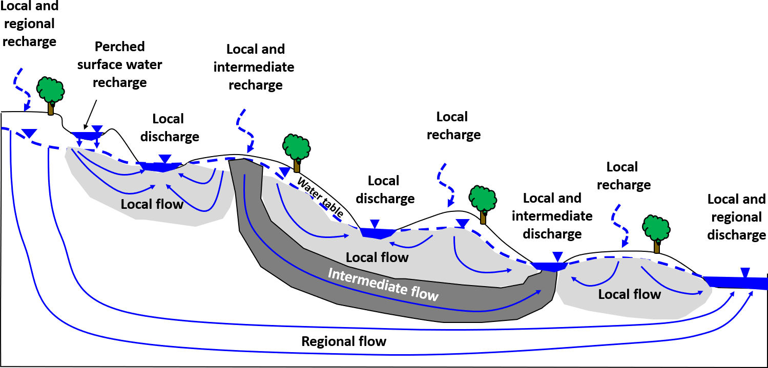
Dynamics of Groundwater Flow Systems: A groundwater system comprises the subsurface water, the geologic media containing the water, flow boundaries, and sources (such as recharge) and sinks (such as springs, inter-aquifer flow, or wells). Water flows through and is stored within that system.
GFS are based on Toth’s conceptual model framework for investigation of unconfined groundwater systems. Groundwater flow systems do not only occur in aquifers, groundwater moves through all the saturated materials between a recharge and discharge area. This can include multiple aquifers (unconfined, and confined) as well as aquitards as illustrated schematically in the figure below. Confined aquifers are recharged at outcrop sites or by downward leakage of water from overlying aquifers. In down gradient areas they may discharge in the form of upward leakage of water into overlying aquifers.